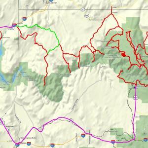
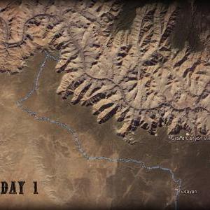
The GCBAR begins at Tusayan, Arizona (the village just outside of the South Rim Entrance Station) and ends in Mesquite, Nevada. Two alternate tracks are included; an exit to Mesquite via Elbow Canyon, plus a paved route around the west from Mesquite to Tusayan for those that wish to complete a loop.
The GCBAR between Tusayan and Mesquite is 1105 miles long - 845 miles or 76% off-road. If the South Rim sections were excluded and one were to start at Buffalo Ranch Road, the route is 820 miles - 92 miles or only 11% paved.
Frequently Asked Questions
What's the best time of year to attempt this route?
Many of these tracks will become completely impassable during wet weather. The upper elevations of the Kaibab Plateau (North Rim) sees significant snowfall that can last fairly late into the season. I once rode in a heavy snowstorm with 2 inches of accumulation in June! The North Rim areas of the National Park are closed from November 1- May 15th. Mid-July, August, and early September are the Monsoon Months with thunderstorms possible nearly every day. The Kaibab Plateau trails usually hold up pretty well under the wet weather, but all of the others get muddy real quick. That leaves June to Early July, or Late September to Late October as the best times to plan. The first week or so of October is usually a good time for fall colors in the aspens - and you will be riding through plenty of aspens. Keep your plans flexible and be willing to change them ahead of the wet weather. Be prepared for huge differences in temperatures. During my October 2013 trip, I saw temps range from 25 to 105 F.
Fuel?
There are waypoints for each fuel station that I'm aware of along the route. (If I have missed any, let me know). Most bikes of normal fuel ranges can do much of the route without an issue. The Western Arizona Strip sections from Fredonia, AZ to Mesquite, NV is at least 373 miles between fuel stations! Located in the middle of this section is the Bar-10 Ranch. This small resort runs ATV tours, so they have a large fuel tank. They are known to sell fuel to motorcyclists. The last report I heard, it was $7 a gallon and they usually average about twice as much as fuel in St. George. Bar-10 is 176 miles from the Judd Chevron in Fredonia and 163 miles from 2 stations in Mesquite. Neither distance includes the 26 miles to Whitmore Overlook and back to Bar-10. The alternate Track 12 to Mesquite via Elbow Canyon adds 11 miles. Carry enough fuel and consider your fuel economy over rugged terrain.
Camping in the National Park?
There are 3 designated campgrounds within the park, as well as lodging. These usually require reservations many months in advance, aren't real close to the rim, and are jam-packed with tourists. Good luck.
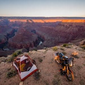
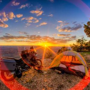
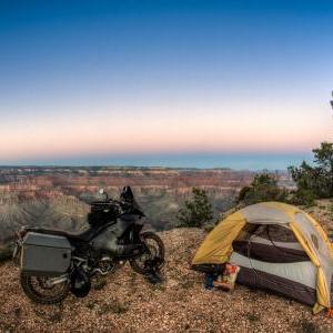
You will be riding to many remote places within the park that are perfect primitive campsites. Camping here requires a backcountry permit. This includes the formerly free campground at Toroweap.
Visit the NPS backcountry permit page for more details:http://www.nps.gov/grca/planyourvisit/backcountry-permit.htm
I have obtained these permits before. There are suggestions in my RRs about camping that I won't go into here... As I understand, the backcountry permit system divides the park to large regions and limits the number of people in that region for each night. Just because no one else is an awesome campsite at Point Sublime or Toroweap doesn't mean they will issue you a permit.
Large sections of this route are in National Forests, BLM land, or other non-park lands. There are tons of free and legal places to camp here. Notable free spots within the national forest with canyon views are Saddle Mountain Trailhead and Crazy Jugs Point.
Tribal Fees?
To reach the incredible Havasupai Pt (the only South Rim backcountry point you can still ride to) you use about 4 miles of road across the Hualapai Reservation. For this privilege, they may charge you $25. It's worth it. Last fall, there was no one to collect my fee at the gate, so I rode around it and entered the reservation anyway. I have no idea how much trouble I may have been in if caught, so I wouldn't recommend the same.
If you wish to ride off-road in the Navajo Nation (Tatahatso Point is on the route) you must obtain a permit at the visitor center in Cameron. It is located on the southwest corner of the roundabout junction of Highways 64 & 89. There is a waypoint in the tracks. The visitor center is open from 8-5, I think. The office is closed on Saturday and Sunday during the winter months. I was there the first week of October 2015 and the nice lady told me it was their last weekend of the season. The fees are reasonable. An overnight camping pass covering 2 days and 1 night was about $18. You can obtain these permits in advance by mail if you know the dates you will be visiting.
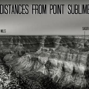
Grand Canyon Backcountry Adventure Route (GCBAR)
Distance
2,477.25 km
Uploaded
7 years ago
Updated
7 years ago
Gravel
Offroad
Inclines
Water
Backcountry GCBAR
Track comments

-
Start of track"GCBAR 1 Havasupai Pt - Tatahatso Pt"
Tusayan, Coconino County, Arizona, 86023, United States of America -
Finish of track"GCBAR 1 Havasupai Pt - Tatahatso Pt"
Coconino County, Arizona, United States of America -
Start of track"GCBAR 10 Whitmore Overlook - Twin Pt"
Mohave County, Arizona, United States of America -
Finish of track"GCBAR 10 Whitmore Overlook - Twin Pt"
Mohave County, Arizona, United States of America -
Start of track"GCBAR 11 Twin Pt - Hidden Canyon - Lime Kiln Pass - Mesquite NV"
Mesquite, Clark County, Nevada, United States of America -
Finish of track"GCBAR 11 Twin Pt - Hidden Canyon - Lime Kiln Pass - Mesquite NV"
Mohave County, Arizona, United States of America -
Start of track"GCBAR 12 Alternate - Elbow Canyon Pass"
Mohave County, Arizona, United States of America -
Finish of track"GCBAR 12 Alternate - Elbow Canyon Pass"
Mesquite, Clark County, Nevada, United States of America -
Start of track"GCBAR 2 Tatahatso - Saddle Mtn"
Coconino County, Arizona, United States of America -
Finish of track"GCBAR 2 Tatahatso - Saddle Mtn"
Coconino County, Arizona, United States of America -
Start of track"GCBAR 3 Saddle Mtn - Jacob Lake - Cape Royal"
Coconino County, Arizona, United States of America -
Finish of track"GCBAR 3 Saddle Mtn - Jacob Lake - Cape Royal"
Coconino County, Arizona, United States of America -
Start of track"GCBAR 4 Cape Royal - Pt Sublime - Timp Pt"
Coconino County, Arizona, United States of America -
Finish of track"GCBAR 4 Cape Royal - Pt Sublime - Timp Pt"
Coconino County, Arizona, United States of America -
Start of track"GCBAR 5 Timp Pt - Crazy Jugs Pt"
Coconino County, Arizona, United States of America -
Finish of track"GCBAR 5 Timp Pt - Crazy Jugs Pt"
Coconino County, Arizona, United States of America -
Start of track"GCBAR 6 Crazy Jugs - Sowats Pt - Jumpup Pt - FR 22"
Coconino County, Arizona, United States of America -
Finish of track"GCBAR 6 Crazy Jugs - Sowats Pt - Jumpup Pt - FR 22"
Ryan, Coconino County, Arizona, United States of America -
Start of track"GCBAR 7 FR 22 - Gunsight Pt - Kanab - Fredonia - Kanab Pt"
Ryan, Coconino County, Arizona, United States of America -
Finish of track"GCBAR 7 FR 22 - Gunsight Pt - Kanab - Fredonia - Kanab Pt"
Mohave County, Arizona, United States of America -
Start of track"GCBAR 8 Kanab Pt - SB Pt - Toroweap Overlook"
Mohave County, Arizona, United States of America -
Finish of track"GCBAR 8 Kanab Pt - SB Pt - Toroweap Overlook"
Mohave County, Arizona, United States of America -
Start of track"GCBAR 9 Toroweap Overlook - Whitmore Overlook"
Mohave County, Arizona, United States of America -
Finish of track"GCBAR 9 Toroweap Overlook - Whitmore Overlook"
Mohave County, Arizona, United States of America -
Start of track"GCBAR Extra - Paved Loop Closure"
Tusayan, Coconino County, Arizona, 86023, United States of America -
Finish of track"GCBAR Extra - Paved Loop Closure"
Mesquite, Clark County, Nevada, United States of America
- Coconino County, Arizona, United States of America
- Road Coconino County, Arizona, United States of America
- Road Coconino County, Arizona, United States of America
- Road Mohave County, Arizona, United States of America
- Road North Rim, Coconino County, Arizona, United States of America
- Road Mount Trumbull, Mohave County, Arizona, United States of America
- Road Coconino County, Arizona, United States of America
- Mohave County, Arizona, United States of America
- Glen Canyon Nat'l Recreation Area Chair Crossing, Coconino County, Arizona, United States of America
- Bright Angel Point Coconino County, Arizona, United States of America
- Road Coconino County, Arizona, United States of America
- Cameron, Coconino County, Arizona, United States of America
- Cape Final Coconino County, Arizona, United States of America
- Road Coconino County, Arizona, United States of America
- Cape Royal Coconino County, Arizona, United States of America
- Bloomington, St. George, Washington County, Utah, UT 84790, United States of America
- Grand Canyon National Park Coconino County, Arizona, United States of America
- 7900 ft Jacob Lake, Coconino County, Arizona, United States of America
- Marble Canyon, Coconino County, Arizona, United States of America
- Co 101 Mohave County, Arizona, United States of America
- Co 103 Mohave County, Arizona, United States of America
- Co 103 and Road Mohave County, Arizona, United States of America
- Co 5 Wolf Hole, Mohave County, Arizona, United States of America
- Cameron, Coconino County, Arizona, United States of America
- Road Mohave County, Arizona, United States of America
- Crazy Jug Point Coconino County, Arizona, United States of America
- Crescent Ridge Coconino County, Arizona, United States of America
- Road Coconino County, Arizona, United States of America
- Road Mohave County, Arizona, United States of America
- Road Mohave County, Arizona, United States of America
- Fence Point Coconino County, Arizona, United States of America
- Road Coconino County, Arizona, United States of America
- Fire Point Coconino County, Arizona, United States of America
- Road Ryan, Coconino County, Arizona, United States of America
- The Gap, Coconino County, Arizona, United States of America
- Grand Canyon West Airport Mohave County, Arizona, United States of America
- Grandview Point Coconino County, Arizona, United States of America
- Coconino County, Arizona, United States of America
- 6700 ft Coconino County, Arizona, United States of America
- Mount Trumbull, Mohave County, Arizona, United States of America
- US 89 Alt Marble Canyon, Coconino County, Arizona, United States of America
- Hoover Dam Clark County, Nevada, United States of America
- Page, Coconino County, Arizona, United States of America
- Hwy 169 Clark County, Nevada, United States of America
- Indian Rte 6110 Coconino County, Arizona, United States of America
- Kaibab National Forest Jacob Lake, Coconino County, Arizona, United States of America
- Fredonia, Coconino County, Arizona, 86020, United States of America
- Trail Coconino County, Arizona, United States of America
- 5800 ft Coconino County, Arizona, United States of America
- Kaibab National Forest Coconino County, Arizona, United States of America
- 5650 ft Mohave County, Arizona, United States of America
- Road Mohave County, Arizona, United States of America
- US 89 Alt and US 89 and E 300 S Kanab, Kane County, Utah, United States of America
- Kelly Point Mohave County, Arizona, United States of America
- Unpaved Road Chair Crossing, Coconino County, Arizona, United States of America
- Kaibab National Forest Coconino County, Arizona, United States of America
- Road Mohave County, Arizona, United States of America
- Lipan Point Coconino County, Arizona, United States of America
- Mohave County, Arizona, United States of America
- Locust Point Coconino County, Arizona, United States of America
- Road Mohave County, Arizona, United States of America
- Road Coconino County, Arizona, United States of America
- 6400 ft Mohave County, Arizona, United States of America
- Kaibab National Forest Coconino County, Arizona, United States of America
- Mesquite, Clark County, Nevada, United States of America
- Monument Point Coconino County, Arizona, United States of America
- Trail Coconino County, Arizona, United States of America
- Kaibab National Forest Coconino County, Arizona, United States of America
- Grand Canyon National Park Mohave County, Arizona, United States of America
- Road Coconino County, Arizona, United States of America
- Navajo Bridge Marble Canyon, Coconino County, Arizona, United States of America
- Navajo Point Coconino County, Arizona, United States of America
- 6100 ft Coconino County, Arizona, United States of America
- Road Coconino County, Arizona, United States of America
- North Rim Entrance Station Coconino County, Arizona, United States of America
- North Timp Point Coconino County, Arizona, United States of America
- 7600 ft Coconino County, Arizona, United States of America
- Nutter Twists Rd Mohave County, Arizona, United States of America
- 5800 ft Coconino County, Arizona, United States of America
- 7600 ft Coconino County, Arizona, United States of America
- Unpaved Road Chair Crossing, Coconino County, Arizona, United States of America
- Parissawampitts Point Coconino County, Arizona, United States of America
- US 89 Cameron, Coconino County, Arizona, United States of America
- Hidden Valley, St. George, Washington County, Utah, 84790, United States of America
- Pipe Spring National Monument Kaibab, Mohave County, Arizona, United States of America
- Point Imperial Coconino County, Arizona, United States of America
- Point Sublime Coconino County, Arizona, United States of America
- Point Sublime Trl Coconino County, Arizona, United States of America
- Indian Rte 6110 Coconino County, Arizona, United States of America
- Road Ryan, Coconino County, Arizona, United States of America
- Road Oak Grove, Mohave County, Arizona, United States of America
- Road Mohave County, Arizona, United States of America
- Kaibab National Forest Coconino County, Arizona, United States of America
- 8800 ft Coconino County, Arizona, United States of America
- 8800 ft Coconino County, Arizona, United States of America
- Mount Trumbull, Mohave County, Arizona, United States of America
- Co 5 and Road and Co 257 Mount Trumbull, Mohave County, Arizona, United States of America
- Cameron, Coconino County, Arizona, United States of America
- Road Mohave County, Arizona, United States of America
- Grand Canyon National Park Mohave County, Arizona, United States of America
- Trail Coconino County, Arizona, United States of America
- Sowats Point Coconino County, Arizona, United States of America
- Buck Rodgers Trading Post Cameron, Coconino County, Arizona, United States of America
- Road Coconino County, Arizona, United States of America
- E Side Game Rd Coconino County, Arizona, United States of America
- 8200 ft Coconino County, Arizona, United States of America
- Road Coconino County, Arizona, United States of America
- Stina Point Coconino County, Arizona, United States of America
- Road Coconino County, Arizona, United States of America
- Swamp Point Coconino County, Arizona, United States of America
- Tatahatso Point Coconino County, Arizona, United States of America
- 5800 ft Coconino County, Arizona, United States of America
- Mesquite, Clark County, Nevada, United States of America
- US 180 Tusayan, Coconino County, Arizona, 86023, United States of America
- Timp Point Coconino County, Arizona, United States of America
- 3550 ft Marble Canyon, Coconino County, Arizona, United States of America
- Road Mohave County, Arizona, United States of America
- Road Mohave County, Arizona, United States of America
- Toroweap Ranger Station Mohave County, Arizona, United States of America
- 5950 ft Mohave County, Arizona, United States of America
- Hidden Valley, St. George, Washington County, Utah, 84790, United States of America
- Page, Coconino County, Arizona, United States of America
- 2350 ft Mohave County, Arizona, United States of America